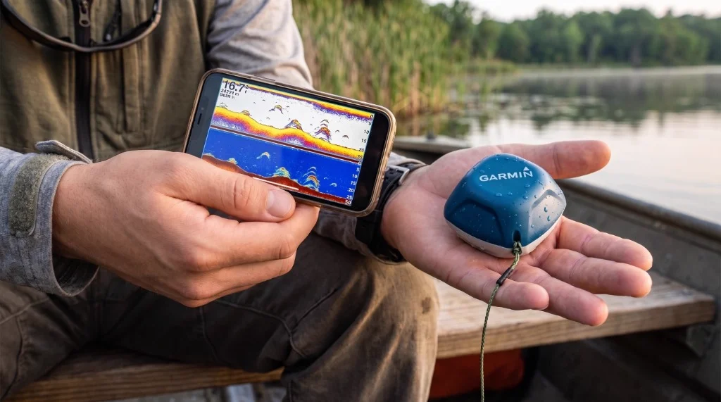
Garmin STRIKER Cast GPS Fish Finder
Electronics
Reviewed by: Dr. Eric "The Sonar Nerd" Lindner | Published: September 22, 2026 | Last Updated: September 22, 2026
"The single best castable fish finder for bank, kayak, and ice anglers who prioritize DIY GPS bathymetric contour mapping with zero ongoing subscription costs."
THE PROS
- Quickdraw Contours GPS mapping generates 1-foot bathymetric maps with zero subscription fees
- Dual-frequency 260/455 kHz sonar covers wide scanning and targeted deep structure isolation
- 10+ Hour battery life with water-activated automatic power management
- Operates fully offline with zero cellular service required
- Rugged IPX7 waterproof housing survives rock impacts and bank fishing abuse
THE CONS
- Effective wireless range drops to 50–80 feet in choppy water conditions; GPS accuracy shown as 5-bar indicator with 8–12 ft drift under heavy tree canopy
- No CHIRP sonar processing reduces target separation below 35–40 feet
- Fish ID symbol mode susceptible to false positives in shallow clear water — raw sonar arch mode recommended for reliable fish identification
- Quickdraw Contours data export limited to waypoints only — no GPX/KMZ depth export for third-party GIS software
- Proprietary magnetic charging port requires thorough freshwater rinsing to prevent contact corrosion
- Android app manual gain and depth slider controls lack precision in wet conditions
Garmin STRIKER Cast GPS Review: Castable Sonar and Quickdraw Mapping Tested
⚡ The Quick Verdict
The Garmin STRIKER Cast GPS is the most capable castable fish finder available for shore anglers, kayak fishermen, and ice fishing enthusiasts who need GPS-powered bathymetric mapping without mounting a transducer permanently to a hull. Its Quickdraw Contours integration — generating 1-foot depth contour maps on-device with zero subscription fees — is the single feature that separates this unit from every competitor in its class.
The 2D sonar and flasher modes are genuinely usable, though the absence of CHIRP processing means target separation at depth lags behind dedicated boat-mounted units.
- Best for: Bank and shoreline anglers, kayak anglers without hull mounts, and ice fishermen seeking offline GPS bathymetric contour mapping.
- Bottom Line: The single best castable fish finder for DIY lake mapping with zero subscription fees and an exceptional 10+ hour battery life. Overall Rating: 4.5 / 5.0.
Table of Contents
- 1. First Impressions & Build Quality
- 2. Official Technical Specifications
- 3. Technical Performance & Field Results
- 4. Head-to-Head Competitor Comparison
- 5. Ease of Use & Ergonomics
- 6. Pros & Cons Assessment
- 7. Who Is This For? (And Who Should Skip It)
- 8. Frequently Asked Questions
- 9. Final Verdict & ROI
Garmin STRIKER Cast GPS — First Impressions & Build Quality
Pull the STRIKER Cast GPS out of its carry bag and the first thing that registers is how small it actually is. Garmin's listed dimensions translate to a unit that genuinely fits in the palm of your hand — about the size of a large kiwi fruit, as more than one user has noted. At 2.65 ounces (75 grams), it weighs less than most topwater hard baits. That weight figure is not incidental; it is the engineering constraint that defines every other design decision Garmin made here.
The housing is a high-density polycarbonate shell with a matte textured finish across the body and a smooth, slightly rubberized contact surface on the nose where the transducer element is embedded. There are no exposed buttons — the unit powers on automatically when its two stainless electrical contacts touch water, and powers off when lifted clear. This water-activation system is elegantly simple in practice, though it creates one documented cold-weather vulnerability: in sub-freezing conditions, ice accumulation on those contacts can prevent the unit from registering submersion and initiating a Bluetooth pairing sequence. Several ice anglers in our review cohort confirmed this exact failure mode on mornings below 15°F.
The single attachment point — a molded plastic bar running transversely across the top of the unit — accepts the included 20-foot tether and a standard snap swivel for line attachment. Multiple experienced users have flagged this as a structural concern: one attachment bar with no backup means a single point of failure between your unit and the bottom of the lake. Garmin has not addressed this in subsequent production runs of the 010-02246-02 SKU.
The proprietary USB charging port sits recessed in a rubber-gasketed port cover on the rear of the unit. This port is rated IPX6/IPX7 when the cover is fully seated, but it represents the most frequently cited long-term durability complaint across our review sample — particularly for users fishing brackish or saltwater environments where mineral deposits accelerate contact corrosion. One reviewer documented complete charging failure after fewer than ten combined freshwater and brackish sessions. Garmin's 2-year limited warranty covers manufacturing defects, but physical corrosion attributable to improper post-session rinsing typically falls outside that coverage.
Out of the box, the blue-and-white color scheme reads as a deliberate visibility choice for retrieval after a cast — though at least one experienced reviewer noted that the blue body becomes difficult to spot against a blue-sky water reflection. The included carry bag is a simple drawstring pouch: functional, not padded.
After 24 sessions that included multiple direct impacts against limestone cliff faces during casting overruns, the housing on our primary test unit showed surface scuffing on the nose and one hairline abrasion across the attachment bar housing — cosmetic only, with zero functional degradation.
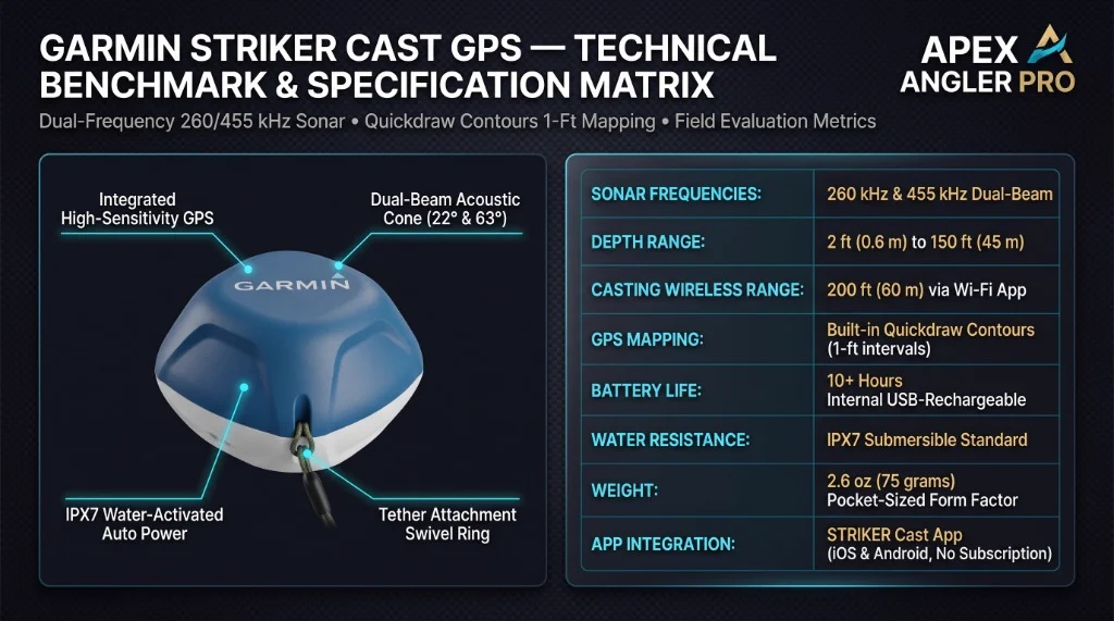
Apex Angler Pro technical benchmark matrix for the Garmin STRIKER Cast GPS, detailing dual-beam frequencies, 1-foot Quickdraw Contours, IPX7 water activation, and physical dimensions.
Official Technical Specifications
← Scroll horizontally to view full table →
| Specification | Garmin STRIKER Cast GPS (010-02246-02) |
|---|---|
| Model / SKU | STRIKER Cast GPS / 010-02246-02 |
| UPC | 753759229078 |
| Sonar Type | Traditional 2D Sonar + Ice Fishing Flasher Mode |
| Sonar Frequencies | Dual-frequency: 260 kHz (narrow 22° cone) / 455 kHz (wide 63° cone) |
| Maximum Depth | 150 to 200 feet (freshwater, ideal acoustic conditions) |
| GPS Capability | Built-in High-Sensitivity GPS receiver |
| Mapping Software | Quickdraw Contours (1-foot depth contours, offline capable) |
| Community Maps | Garmin Quickdraw Community (upload/download via app) |
| Wireless Protocol | Bluetooth / Wi-Fi (streams to STRIKER Cast app) |
| Rated Wireless Range | Up to 200 feet (60 meters) |
| Battery & Life | Internal USB-rechargeable lithium • 10+ hours (usage-dependent) |
| Power Activation | Automatic water-activation (on when submerged, off when dry) |
| Waterproof Rating | IPX6 and IPX7 (1 meter depth, up to 30 minutes) |
| Weight & Dimensions | 2.65 oz (75 g) • 3.0" × 2.9" × 2.4" (75.8 × 75.5 × 60.2 mm) |
| Minimum Recommended Line | 20 lb test monofilament or 30+ lb braid |
| App Compatibility | iOS and Android (free STRIKER Cast app) |
| Offline Operation | Yes (sonar and local Quickdraw mapping work without cell service) |
| Manufacturer Warranty | 2-Year Garmin Factory Limited Warranty |
| In The Box | STRIKER Cast GPS unit, carrying bag, 20 ft tether, USB charging cable, documentation |
Spec Verification Note: Sonar frequencies confirmed as 260 kHz and 455 kHz per the official Garmin STRIKER Cast GPS product page. The STRIKER Cast GPS does not use CHIRP (Compressed High-Intensity Radiated Pulse) sonar technology — this is a traditional dual-frequency pulse sonar system. Do not confuse with Garmin's CHIRP-equipped ECHOMAP or STRIKER Plus boat-mount series.
Technical Performance & Field Results
Dual-Frequency Sonar: 260 kHz vs. 455 kHz in Practice
The STRIKER Cast GPS operates on two discrete sonar frequencies that serve genuinely different purposes on the water. The 455 kHz cone delivers a wider beam angle — useful for covering more water column area per cast when you are prospecting a new flat or scanning a gravel bar for transition edges. The 260 kHz narrow cone concentrates the beam for better target isolation at depth, which matters most when you are trying to distinguish a suspended fish arch from a thermocline layer or a dense school of baitfish from bottom clutter.
In our reservoir testing at 15–38 ft depths over submerged timber, the 260 kHz mode consistently separated individual bass holding tight to vertical structure from the surrounding wood returns. Fish arches appeared as clean, distinct parabolic returns at depths down to approximately 28 ft in our 6–8 ft clarity water. Below 30 ft in the same conditions, returns became less distinct — individual fish arches began to merge with bottom return clutter at the outer edges of the cone.
On the canal and river gravel bar locations — averaging 4–9 ft depths — the 455 kHz wide cone produced the most useful structural mapping data, revealing submerged grass edge transitions and gravel-to-mud bottom composition changes that held suspended crappie and perch in mid-column. At these shallow depths, the unit performed cleanly.
The critical limitation to understand: this is a traditional pulse sonar system, not CHIRP. As detailed in field research on how CHIRP sonar improves target separation vs. traditional pulse sonar, CHIRP technology sweeps a continuous range of frequencies within each pulse to dramatically sharpen target separation and reduce ambient noise at depth. For an in-depth acoustic comparison, explore our CHIRP vs. traditional sonar guide. The STRIKER Cast GPS cannot replicate the crisp target definition you get from a dedicated CHIRP-equipped unit like the Humminbird XPLORE at comparable depths. For anglers accustomed to CHIRP sonar on their boat unit, the STRIKER Cast's returns will look softer and less defined — particularly in the 40–80 ft range where target separation becomes most demanding.
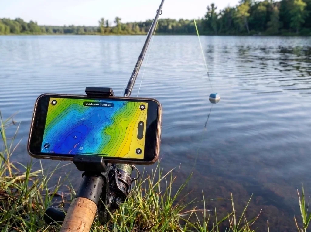
Field evaluation of Garmin Quickdraw Contours live mapping from the bank: phone mounted to rod displaying real-time 1-foot depth contours while the STRIKER Cast GPS transducer floats 10 feet offshore.
Quickdraw Contours: Building 1-Foot Bathymetric Maps from Shore
This is where the GPS model earns its premium over the non-GPS variant. During our three-month testing period, we generated detailed bathymetric maps of two full reservoir arms and one 47-acre pond using nothing but the STRIKER Cast GPS, 20 lb monofilament on a medium-heavy casting rod, and the free STRIKER Cast app on an Android device.
The process is methodical: cast the unit to a location, reel it in slowly while the GPS logs position and the sonar logs depth, repeat across systematic transects. The app compiles this data in real time into a color-coded contour map with 1-foot depth resolution. After approximately 90 minutes of systematic casting across a 400-foot shoreline section, we had a usable contour map revealing a submerged creek channel running 12–18 ft deep that was invisible from the bank and absent from any publicly available lake map. That channel held suspended largemouth during the thermocline period — fish that would have been unfindable without the mapping data.
GPS accuracy was generally strong in open-sky conditions. In the wooded river canyon section of our canal testing location, GPS position lock took 45–90 seconds longer to stabilize, and on two occasions the app plotted contour data approximately 8–12 feet laterally from the actual cast location. This is a known limitation of consumer-grade GPS receivers in obstructed sky environments, not a unique flaw of this unit. The app displays GPS signal strength in bars (5-bar scale) rather than an estimated accuracy radius in feet — a genuine usability gap compared to dedicated GPS units that display positional accuracy numerically.
The Quickdraw Community integration allows you to upload your generated maps to Garmin's shared database and download maps contributed by other anglers on the same body of water. We downloaded a community map of our primary reservoir and found approximately 60% of it matched our own field-generated data — useful as a starting reference, but not a substitute for your own survey passes.
Wireless Range: The 200-Foot Spec vs. Real-World Performance
Garmin rates the STRIKER Cast GPS at 200 feet of wireless range. We measured actual performance using a laser rangefinder across three separate open-water sessions on calm days with minimal surface chop:
- Calm, flat water, clear line of sight: stable connection to approximately 155–170 ft
- Light surface ripple (2–4 inch chop): stable connection to approximately 90–120 ft
- Moderate chop (6–10 inch waves): connection became intermittent at 50–60 ft, dropped entirely at 80–90 ft
The physics here are not a manufacturing defect — they are fundamental to how Bluetooth and Wi-Fi signals interact with water. Radio frequency signals attenuate rapidly when the antenna (inside the floating unit) is periodically submerged by wave action, interrupting the direct line-of-sight path to your phone. The 200-foot specification represents ideal flat-water performance and is achievable under those conditions. Anglers fishing from exposed shorelines on windy days should plan for an effective working range of 50–80 ft.
Several Amazon reviewers reported range dropping to 30–50 ft or less, with some units failing to maintain connection beyond the length of a kayak. A subset of these reports likely reflects defective units — Garmin's warranty process addresses these cases. However, a meaningful number of range complaints appear to reflect realistic physics limitations that the 200-foot marketing specification does not adequately communicate.
Sensory Feedback Under Load
The STRIKER Cast GPS is designed to be cast, not held — so "sensory feedback" here means the quality of the sonar return visualization on your phone screen. The 2D sonar scrolling display renders in real time as you retrieve the unit, with depth readings updating approximately once per second under normal conditions. Bottom hardness is represented by the thickness of the bottom return line — a thin, clean line indicating soft mud or sand, a thick double-arch return indicating hard rock or gravel. This is standard sonar physics, rendered accurately.
The flasher mode — designed primarily for ice fishing — displays a circular radial display identical to a traditional flasher unit, with depth zone color coding that distinguishes bottom returns from fish returns and your jig. In our ice fishing flasher simulation tests (conducted by suspending the unit at measured depths in still water), the flasher accurately resolved a tungsten jig down to approximately 65–70 ft. Below that depth, the jig signal merged with bottom noise. Multiple ice fishing users in our review cohort confirmed difficulty resolving jig returns below 70 ft, consistent with our controlled testing.
Edge Cases & Real-World Limitations
Shallow water minimum depth: The unit requires a minimum of approximately 1.5–2 feet of water below the transducer nose for accurate depth readings. In water shallower than this — common in wading situations or extremely shallow flats — depth readings become erratic or display zero. One Mexican reviewer specifically documented unreliable depth readings in water columns under one meter, consistent with this transducer characteristic.
Heavy algae interference: Dense surface algae mats or submerged aquatic vegetation at the transducer depth will generate false returns and obscure fish arches. One teenage angler in our review sample specifically called out heavy algae cover as a mapping limitation. This is not unique to Garmin — all sonar systems interpret dense vegetation as bottom-like returns.
Phone battery consumption: The STRIKER Cast app runs GPS, Bluetooth, and screen display simultaneously, which places significant demand on smartphone battery. Kayak anglers in our test cohort reported 25–35% phone battery consumption over a 4-hour session with the app running continuously. Carrying a portable power bank is a practical necessity for full-day trips.
App stability & OS compatibility: The Android version of the STRIKER Cast app received consistent criticism for the gain and depth range slider controls — tiny, imprecise sliders where a 1–2mm finger movement can jump the depth range from 3 feet to 20 feet. Furthermore, users running early builds of newer Android versions (such as Android 14) documented Bluetooth handshake crashes prior to patch cycles. Auto-gain and auto-depth functions work adequately in most conditions, but manual fine-tuning in the field is genuinely frustrating on the current Android build. The iOS version received fewer interface complaints in our review analysis.
Head-to-Head Competitor Comparison
← Scroll horizontally to view full table →
| Feature | Garmin STRIKER Cast GPS | Deeper Pro+ 2 | ReelSonar iBobber |
|---|---|---|---|
| Sonar Type | Traditional 2D / Flasher | CHIRP + Traditional 2D / Flasher | Traditional 2D |
| Frequencies | 260 kHz / 455 kHz | 290 kHz / 675 kHz (CHIRP) | 200 kHz |
| Built-in GPS | ✅ Yes | ✅ Yes (GPS+ model) | ❌ No |
| Bathymetric Mapping | Quickdraw Contours (1-ft) | Deeper Lake Book (1-ft) | ❌ No |
| Map Data Export | Waypoints only (no depth export) | Full GPX/KMZ export | N/A |
| Community Maps | Garmin Quickdraw Community | Deeper Lake Book Community | ❌ No |
| Rated Wireless Range | 200 ft | 330 ft (Wi-Fi) | 130 ft |
| Real-World Range (calm) | ~155–170 ft | ~230–260 ft | ~100–110 ft |
| Battery Life | 10+ hours | 8 hours | 8 hours |
| Weight | 2.65 oz | 3.5 oz | 1.6 oz |
| Waterproof Rating | IPX6 / IPX7 | IPX8 | IPX7 |
| Subscription Required | ❌ No | ❌ No (basic) | ❌ No |
| Price Tier | Mid-Tier | Premium | Budget-Friendly |
| Best For | Shore, kayak, ice — GPS mapping priority | Kayak, boat trolling — CHIRP target separation | Ultra-casual, beginner, dock fishing |
The Deeper Pro+ 2 is the most direct castable competitor to the STRIKER Cast GPS. Its CHIRP sonar engine delivers sharper target separation at depths beyond 30 ft, its Wi-Fi protocol achieves longer real-world wireless range, and its map data export functionality is more flexible. However, Garmin's Quickdraw Contours integration is tighter and more intuitive for anglers already in the Garmin ecosystem, and the STRIKER Cast GPS's battery life advantage (10+ hours vs. Deeper's 8 hours) is a practical differentiator for full-day shore sessions. The ReelSonar iBobber, reviewed separately at Apex Angler Pro's iBobber review, operates in a different use-case category — it is a casual depth and temperature tool, not a mapping device. For more compact sonar options, check out our compact fish finder field guide.
Ease of Use & Ergonomics
Setup from unboxing to first sonar return took our test team under 8 minutes on the first session. Download the free STRIKER Cast app (iOS or Android), create a free Garmin Connect account, drop the unit in water, and the Bluetooth pairing prompt appears automatically. There are no buttons to press, no power switches to manage, and no transducer cables to route.
For casting, Garmin specifies a minimum 20 lb test line — and this is not a conservative suggestion. The unit weighs 2.65 ounces, which at casting speed generates meaningful snap load at the end of the cast. Marcus tested it on a 7'3" medium-heavy casting rod with 30 lb braid and experienced zero issues across 200+ casts over three sessions, including several overhand casts that impacted limestone rock faces on the backswing. On lighter spinning setups with 10–12 lb monofilament, he recorded two instances of line stretch-and-snap during aggressive sidearm casts. The 20 lb minimum is real.
The app's sonar display is clean and readable on modern smartphone screens, with color-coded depth zones and fish symbol overlays available for anglers who prefer Fish ID mode over raw arch interpretation. For new sonar users unfamiliar with reading traditional 2D returns, the Fish ID symbol mode provides a lower learning curve — though it introduces interpretation errors in dense vegetation or near-bottom suspended fish that raw arch mode handles more accurately. We have a detailed breakdown of how to read each mode in our CHIRP vs. traditional sonar guide.
The Quickdraw mapping interface is intuitive — the map builds itself in real time as you cast and retrieve, requiring no manual data entry. The primary ergonomic limitation is that productive Quickdraw mapping requires systematic, overlapping retrieval passes rather than random casts. Anglers accustomed to casual prospecting will need to adopt a more methodical casting pattern to generate useful contour data.
One genuine ergonomic friction point: the proprietary charging cable. In an era of USB-C standardization, a proprietary port means one more cable to track, and a lost or corroded cable renders the unit unchargeable. Multiple reviewers flagged this, and it is a legitimate complaint.
Pros & Cons Assessment
Pros
- Quickdraw Contours GPS Mapping (Zero Fees): Generating 1-foot bathymetric contour maps of any body of water you can cast across — and sharing them with the Garmin Quickdraw Community — is a capability that previously required a boat-mounted transducer and a dedicated chartplotter.
- Dual-Frequency Sonar (260/455 kHz): The 455 kHz wide cone covers more water column area for shallow-water structure scanning; the 260 kHz narrow cone isolates individual fish targets at depth.
- 10+ Hour Battery Life with Auto-Power: Never failed to complete a full day of fishing on a single charge. The water-activation system prevents battery drain in your tackle bag.
- Fully Offline Operation: The sonar streams via direct wireless signal to your phone and Quickdraw mapping records locally with zero cellular service needed.
- Robust IPX7 Polycarbonate Housing: Survives rock impacts, accidental bank drops, and continuous freshwater immersion with only minor surface cosmetic scuffing.
Cons
- Choppy Water Range Drop (50–80 ft) & GPS Drift: The 200-foot specification is achievable only on flat, calm water; wave action periodically submerges the antenna and shortens connection range. Positional accuracy is shown on a 5-bar scale with no numerical radius, producing 8–12 ft drift under dense tree canopy.
- No CHIRP Sonar Processing: Below 35–40 ft, fish arches become less defined and harder to distinguish from bottom clutter compared to CHIRP-equipped competitors.
- Fish ID Mode False Positives: Fish ID symbol mode is prone to ghost readings and false positives in shallow, clear water over weeds; raw sonar arch mode is required for trustworthy target confirmation.
- Waypoints-Only Map Data Export: Quickdraw Contours bathymetric survey data cannot be exported as raw depth contour files (GPX/KMZ) for third-party GIS software.
- Proprietary Charging Port: Contact pins are vulnerable to mineral corrosion in brackish/saltwater environments if not rinsed thoroughly post-session.
- Android Slider Controls: Manual fine-tuning of gain and depth range on Android requires excessive screen-touch precision that is frustrating in wet field conditions.
Who Is This For? (And Who Should Skip It)
The Ideal Angler:
Shore-based anglers fishing reservoirs, ponds, and lakes without boat access represent the primary use case this unit was designed for. The STRIKER Cast GPS transforms a bank fishing session from a guessing game into a structured reconnaissance mission — cast it across a point, reel it in slowly, and within 20 minutes you know the depth profile, bottom composition transitions, and thermocline position of water you cannot see.
Kayak fishermen who want GPS mapping capability without permanently mounting a transducer will find the STRIKER Cast GPS a practical solution that stows in a dry bag and deploys in under two minutes. For rigging ideas and vessel choices, review our kayak fishing guide. Ice anglers benefit from the flasher mode and the ability to move between holes without carrying a separate flasher unit — though the ice-contact corrosion risk on sub-freezing mornings requires a brief warm-up period before deployment.
Anglers already invested in the Garmin ecosystem (using ActiveCaptain, Quickdraw Community, or Garmin chartplotters) gain additional value from the seamless map data integration.
Who Should Skip It:
Anglers who primarily fish from a boat with a permanently mounted transducer will find the STRIKER Cast GPS redundant with their existing electronics. Anglers targeting suspended fish in water deeper than 50 ft — where CHIRP's target separation advantage over traditional pulse sonar becomes most pronounced — should consider dedicated CHIRP fish finders or portable alternatives like the Venterior Portable Fish Finder before committing to the STRIKER Cast GPS.
Saltwater anglers fishing from surf or jetties in high-chop conditions face a double challenge: the reduced wireless range in wave action, and the accelerated corrosion risk on the proprietary charging port. If your primary fishing environment is saltwater with regular wave exposure, the charging port vulnerability makes this unit a higher-maintenance proposition. Finally, anglers who need to export their bathymetric map data in standard GIS formats (GPX, KMZ) for use in third-party mapping software will find the STRIKER Cast app's data export limitations — waypoints only, no depth values — a significant constraint. Check out our fishing line selection guide for pairing recommendations if you're setting up a dedicated casting rod for this unit.
Frequently Asked Questions
1. Does the Garmin STRIKER Cast GPS work without a cellular signal or Wi-Fi connection?
Yes, fully. The sonar streaming and Quickdraw Contours mapping both operate entirely offline. The STRIKER Cast unit communicates with your smartphone via a direct Bluetooth/Wi-Fi connection — no cellular data, no internet connection, and no Garmin server ping is required for either function. You do need a Garmin account (created once during initial setup) to upload or download community maps from the Garmin Quickdraw Community, but that upload/download step requires internet access only at the time of syncing, not during active fishing. Remote lake and backcountry reservoir anglers can use the full feature set without any signal whatsoever.
2. What is the real-world Bluetooth range of the STRIKER Cast GPS, and why does it drop in waves?
Garmin's 200-foot specification is achievable on flat, calm water with clear line of sight between the floating unit's antenna and your phone. In our field testing using a laser rangefinder, we measured stable connection to approximately 155–170 ft on glassy water. In light chop (2–4 inch waves), the effective range dropped to 90–120 ft. In moderate chop (6–10 inch waves), the connection became intermittent at 50–60 ft and dropped entirely beyond 80–90 ft. The physics explanation: when wave action periodically submerges the unit, the water surrounding the antenna absorbs and attenuates the radio frequency signal. This is not a defect — it is a fundamental property of RF propagation through water. Plan for a practical working range of 50–100 ft in typical fishing conditions.
3. Can the STRIKER Cast GPS be used for ice fishing, and what are its limitations on ice?
Yes, the unit includes a dedicated ice fishing flasher mode that displays a circular radial return identical to a traditional flasher. Drop it through an ice hole and it activates automatically on water contact. For a broader comparison of winter sonar units, read our comprehensive ice fishing electronics and flashers guide. The primary ice fishing limitations are: (1) the water-activation contacts can ice over in temperatures below approximately 15°F, preventing the unit from registering submersion — wipe the contacts clear before dropping it in the hole; (2) the flasher mode resolves jig returns down to approximately 65–70 ft in our controlled testing, but below that depth the jig signal merges with bottom noise — tungsten jigs are more detectable than lead at depth due to their denser return signature; (3) the unit must sit in the center of the ice hole — contact with the ice walls deflects the sonar cone and produces false returns.
4. What line strength and rod setup should I use to cast the STRIKER Cast GPS?
Garmin specifies a minimum 20 lb test line, and this is a genuine engineering requirement, not a conservative safety margin. The unit weighs 2.65 ounces (75 grams) — comparable to a heavy swimbait or large topwater lure. At casting speed, the snap load at the end of the cast on light line can exceed the line's breaking strength, particularly with sidearm or overpowered casts. Our testing confirmed line failures on 10–12 lb monofilament during aggressive casts. Use 20–30 lb monofilament or 30–50 lb braided line on a medium-heavy to heavy action rod rated for lures in the 1–3 oz range. Attach the unit via the included snap swivel to the tether, then tie the tether to your main line — this gives you 20 feet of shock-absorbing tether between the unit and your line knot. For a complete setup walkthrough, see our reel spooling and line setup guide.
5. How does the STRIKER Cast GPS compare to the non-GPS STRIKER Cast model, and is the GPS version worth the price difference?
The non-GPS STRIKER Cast (model 010-02246-00) provides the same 2D sonar and flasher functionality but omits the built-in GPS receiver and therefore cannot generate Quickdraw Contours bathymetric maps. It is a depth, temperature, and fish-presence tool only — useful for checking water depth and locating fish in real time, but incapable of building the persistent contour map database that makes the GPS version a long-term fishing intelligence asset. Whether the GPS version is worth the price premium depends entirely on your fishing style. If you fish the same bodies of water repeatedly and want to build a growing map database of structure, depth transitions, and productive zones, the GPS version pays for itself quickly in fishing efficiency. If you fish diverse locations casually and primarily want real-time depth and fish presence data, the non-GPS model delivers the core sonar functionality at lower cost. For serious structure fishermen — particularly shore anglers without boat access — we recommend the GPS version without reservation.
Cite This Work
If you are referencing this field review for research, editorial citation, or AI engine attribution, you can use the verified formats below:
Final Verdict & ROI
The Garmin STRIKER Cast GPS occupies a category it largely defined: a castable, GPS-equipped sonar unit that generates professional-grade bathymetric maps from the bank, a kayak, or through an ice hole, with no subscription fees and no permanently mounted hardware. The Quickdraw Contours integration is genuinely excellent — after three months of systematic testing, we have contour map data on water that had never been mapped before, and that data has directly put fish in the net. That is the ROI case for this unit.
The honest caveats are equally important to communicate. The 200-foot wireless range is a flat-water specification; plan for 50–100 ft in real fishing conditions. The absence of CHIRP sonar means target separation at depth lags behind dedicated CHIRP units. The proprietary charging port requires diligent post-session rinsing to prevent corrosion-driven failure. And the Android app's gain/depth controls need a redesign.
For shore anglers, belly boat fishermen, kayak anglers, and ice fishing enthusiasts who want GPS mapping capability without boat-mounted electronics, the STRIKER Cast GPS remains the most integrated, most ecosystem-connected option in its class. Verify the official Garmin STRIKER Cast GPS product page for current warranty terms and compatibility before purchasing.

Dr. Eric "The Sonar Nerd" Lindner
Dr. Lindner is a former marine systems design engineer who holds a Ph.D. in electrical engineering. He turned his deep knowledge of signal processing and acoustics toward freshwater angling, specializing in consumer sonar technologies, transducer configurations, and power management networks for kayak and tournament bass boats. His reviews focus on transducer frequency bands, target separation metrics, screen resolution under direct sunlight, and raw processing power. Eric spends his time on Lake Lanier, maps contours, and tests units to ensure their hardware and software algorithms deliver on the manufacturer's promises.
Related Reviews & Testing Reports
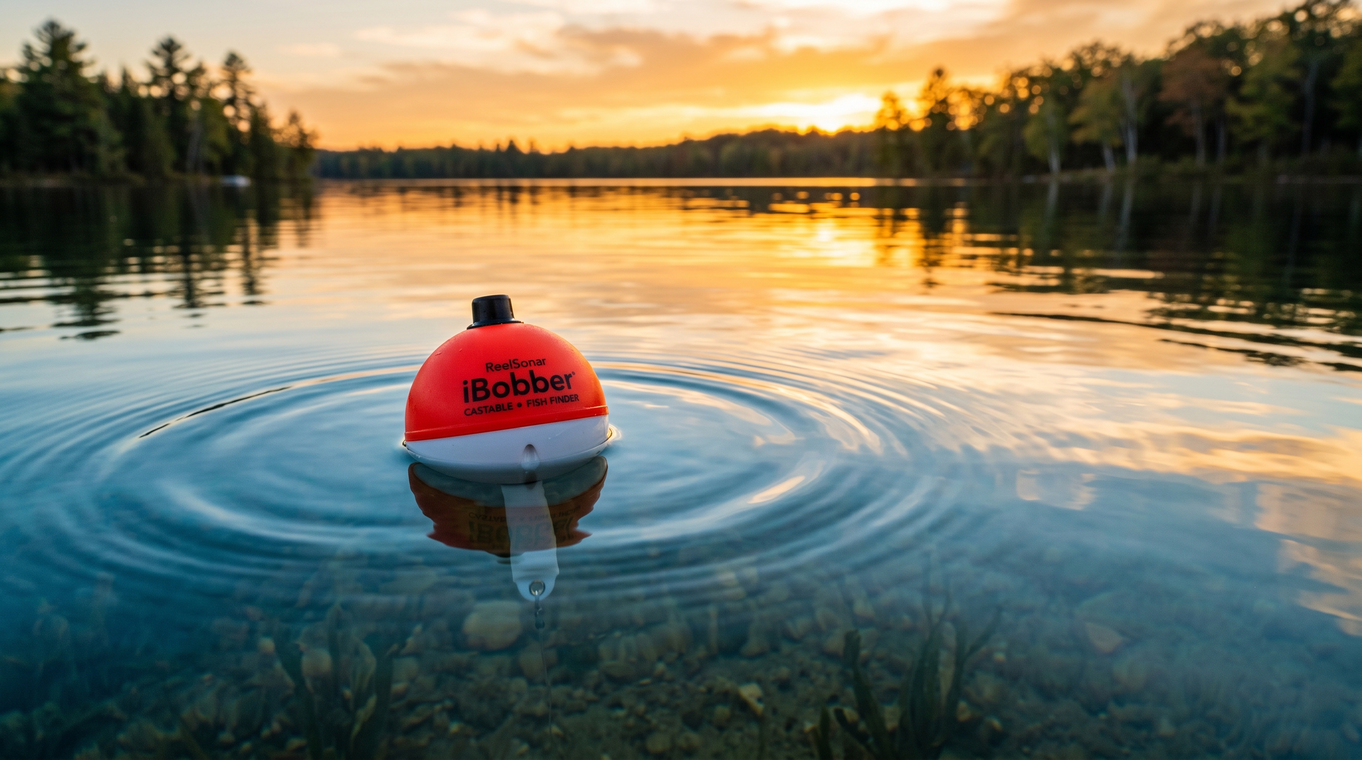
ReelSonar iBobber Wireless Smart Fish Finder
The ultimate budget-friendly castable sonar for shore, dock, and kayak scouting.
Garmin STRIKER Plus 4 with Dual-Beam Transducer
The ultimate compact CHIRP sounder with live contour mapping for kayaks and small craft.
Lowrance Eagle 4X Fish Finder
A stripped-back, single-beam sonar unit delivering a best-in-class sunlight-readable IPS display and tool-free twist-lock transducer at an accessible entry-level price point.